Product & Innovation
Issy-les-Moulineaux: 19,850 trees rendered in 3D thanks to AI
Vectuel enhances Mappr with AI: Issy-les-Moulineaux's 19,850 trees rendered in 3D using the IGN's HD LiDAR and its 2025 oblique acquisition campaign, accessible directly on the City's website.
·
3 min read
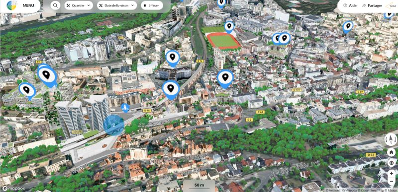
Vectuel takes a new step in the evolution of Mappr, its 3D mapping platform, by augmenting it with AI: the 19,850 trees in Issy-les-Moulineaux have been individually rendered in 3D, using IGN's LiDAR HD data and the studio's 2025 oblique acquisition campaign, with the support of Issy Media. The result can be accessed directly on the City's website.
How does AI reconstruct a tree heritage in 3D?
The process cross-references several sources and automates each step: identification and segmentation of canopies in the LiDAR HD point cloud, cross-reprocessing with classified building and road data, cross-referencing with the 2025 orthophoto and high-resolution oblique images, and then optimized 3D reconstruction taking heights into account and dynamic integration into Mappr. Where a manual inventory would take months, AI produces a faithful and measurable representation of the entire plant heritage.
What is a 3D tree heritage used for?
First, for transparency: the platform accurately reflects the planting of more than 6,000 trees since the beginning of the term, offering a clear reading of the environmental commitments made. Second, for management: concretely visualizing public policies, measuring the evolution of the green heritage, tracking commitments over time, and making territorial data intelligible to everyone. AI is not just a buzzword: it is an operational lever for managing the sustainable city.
Towards an environmental digital twin
Vegetation is a key data point for climate adaptation: canopy, shade, heat islands, open ground. By integrating it natively into Mappr, Vectuel is preparing the convergence between the urban digital twin and environmental challenges — the same logic that guides PLU 3D, its winning project for Innov'up Experiméntation, and which aligns with the national ambition of the JUNN program.
Frequently Asked Questions
How many trees have been modeled?
19,850 trees, individually rendered in 3D, including more than 6,000 planted since the beginning of the term.
What data was used?
IGN's LiDAR HD data, Vectuel's 2025 oblique acquisition campaign, and the 2025 orthophoto.
Where can I view the result?
The 3D rendering is accessible directly on the website of the City of Issy-les-Moulineaux, via the Mappr platform.